Navionics Platinum+ 900PP - West Great Lakes - CF Card
Platinum+ - West Great Lakes - CF Format
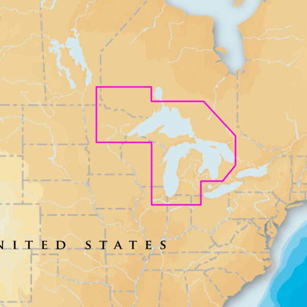
Covers: MICHIGAN, SUPERIOR, HURON Including Lake of the Woods, Rainy Lake, North Channel, Georgian Bay, Green Bay and Lake Winnebago.
Multi-dimensional marine charts include comprehensive Nautical Chart, incredible fishing detail with SonarChart 1 ft HD bathymetry map, and Community Edits. Plus, exclusive Platinum features take the boating experience to a whole new level: 3D view, high-resolution photo/chart overlay, port photos, and geo-referenced coast pilots. Register online for one year of daily updates to Nautical Chart, SonarChart and Community Edits.
Visit Navionics.com/downloads-updates to enjoy preloaded content and download the latest charts.
Enhance SonarChart with sonar logs you collect using a plotter or mobile device.
High-definition fishing detail, 3D View, Satellite overlay, port photos, tides & currents, safety depth contours, navaids, coastal points of interest, and port services information.
Check compatibility at Navionics.com, which is continuously update.
<
Product : NAVIONICS PLATINUM PLUS WEST GREAT LAKES CF/900P+
Manufacturer : NAVIONICS
Manufacturer Part No : CF/900P+
UPC : 821245900586
Covers: MICHIGAN, SUPERIOR, HURON Including Lake of the Woods, Rainy Lake, North Channel, Georgian Bay, Green Bay and Lake Winnebago.
Multi-dimensional marine charts include comprehensive Nautical Chart, incredible fishing detail with SonarChart 1 ft HD bathymetry map, and Community Edits. Plus, exclusive Platinum features take the boating experience to a whole new level: 3D view, high-resolution photo/chart overlay, port photos, and geo-referenced coast pilots. Register online for one year of daily updates to Nautical Chart, SonarChart and Community Edits.
- One Foot Contours Inshore and Nearshore
- 3ft and 6ft Contours Offshore Beyond 90ft
- 3D View
- Satellite Overlay
- Port Photos
- SonarChart
- Tides & Currents
- Safety Depth Contours, Navaids
- Coastal Points-Of-Interest
- Port Services Information
Visit Navionics.com/downloads-updates to enjoy preloaded content and download the latest charts.
Enhance SonarChart with sonar logs you collect using a plotter or mobile device.
High-definition fishing detail, 3D View, Satellite overlay, port photos, tides & currents, safety depth contours, navaids, coastal points of interest, and port services information.
Check compatibility at Navionics.com, which is continuously update.
<
Product : NAVIONICS PLATINUM PLUS WEST GREAT LAKES CF/900P+
Manufacturer : NAVIONICS
Manufacturer Part No : CF/900P+
UPC : 821245900586